
 Crew : 10
Transportation : Cars
Duration : Half a day (another half day may be needed to visit the “Mahaweli Maha Seya”, ruins of “Kadadora” entarnce and ambalama)
One weekend, one of my friends told me that he and his relatives are visiting a pirivena (School for monks) in Kothmale area to offer Thripitaka (The Buddhist Holy Book which consist of three sub sections;”Sutra pitaka”, “Vinaya pitaka”, “Abhidarma pitaka”). I wanted to join to the journey as I hadn’t been there to Kothmale before.
………………………………………………………………………………………………………………………………….. …………………………………………………………………………………………………………………………………..
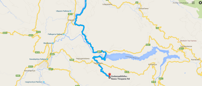
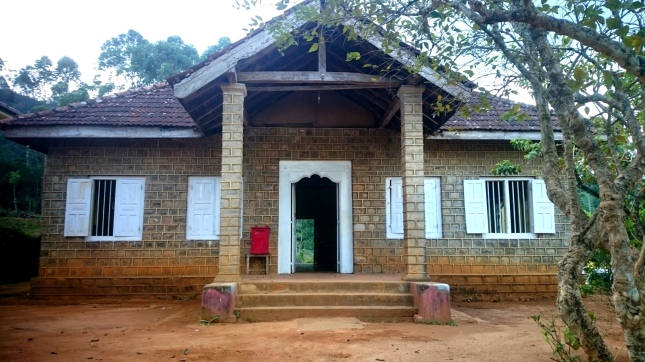
Name of the shrine is “Gunarathana Piriwena” and it is located in Harangala area. We used Kandy – Nawalapitiya Road (AB13) and turned to Nawalapitiya – Harangala Road (B506) from Nawalapitiya Town and traveled 13 kms to reach there. The road conditions from Nawalapitiya to the location was not good and it took around 30 mins to travel that 13 kms. But later we heard the road from Ulapane to Harangala (B431) through kothmale Dam is in better conditions, so we used it to travel back home (this is the route shown in the map above). We though of having our lunch on the way, but we were already in Nawalapitiya – Harangala Road before realizing that there are no place to buy lunch there. So we bought a packet of biscuits and “Gnana Katha” (A bun shaped hard cake decorated with sugar) and had it on the way.
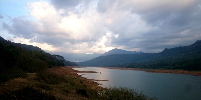
The road was along Kothmale reservoir which gave us a stunning ,a movie like view though the water level of the reservoir was very low with the delayed monsoon rains. we arrived to the Pirivena around 2pm and offered the Tripitaka to the Chief incumbent and several other monks after observing pansil. The shrine looked old but the environment was very calm and relaxing. The locals had arranged us some tea along with Dodol , Rulang , Cashews and Bananas.
😀
It was the best Dodol I have ever had!
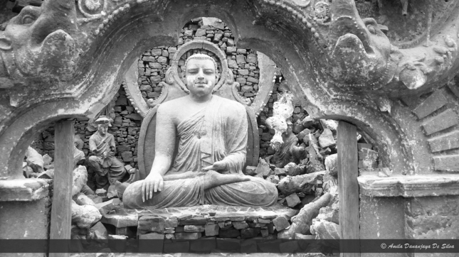
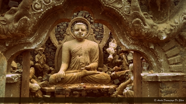
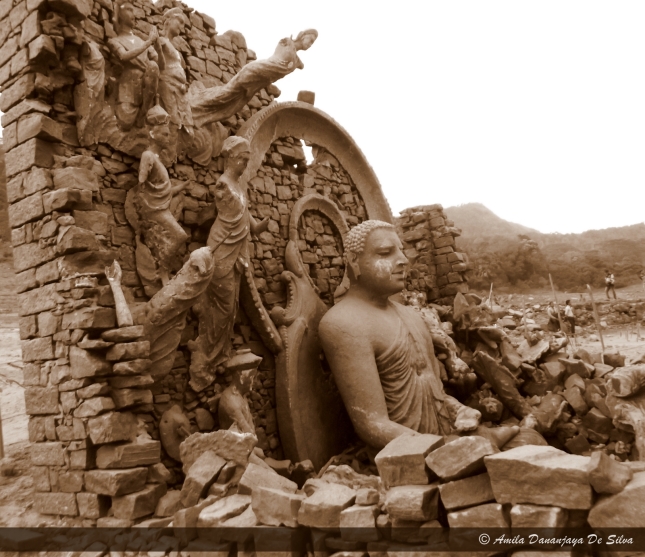
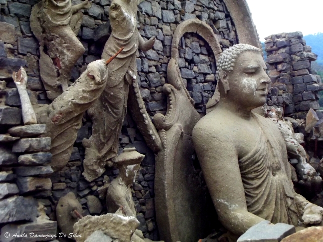
As the planned activity was over, we thought of visiting the ruins of a submerged temple in Kothmale reservoir which are now surfaced due to the low water levels. We traveled through the Kothmale Dam and reached Kothmale reservoir observation point, parked our vehicles there and started walking downward. Though the banks of the reservoir is named as a forest reserve and normally do not allow public to travel, the authorities have allowed people to go down there and visit the ruins as this is a very rare incident. We had to walk through a jungle for about one kilometer and a steep river bank.
I had seen few photographs of previous travelers who were the few days back, but the environment was totally different that day. A local travel show had telecast a documentary filmed on this location, which increased the number of visitors so someone built a fence using sticks and used red flags to mark the boundaries which the visitors can enter without damaging the ruins. In the point of preserving the ruins, it is a good idea but it was very hard to capture the ruins without disturbance from the red flags.
We spent a good half an hour admiring the quality of building which still standing up even after spending around 30 years submerged. It was sad to see the marks which seemed to have occurred in an attempt to dig the statues for treasures.
Here are some facts about this area and the temple which i found very interesting,
This area has a very important place in history books as the great king Dutugamunu’s (161BC – 131BC) life tale is based on Kothmale. Before that era, the King Panduwasadeva (504BC – 474BC) is said to held a dance by the Yak (devil) tribes in this area which was referred “Malaya Rata” at that time.
…………………………………………………………………………………………………………………………………..
…………………………………………………………………………………………………………………………………..
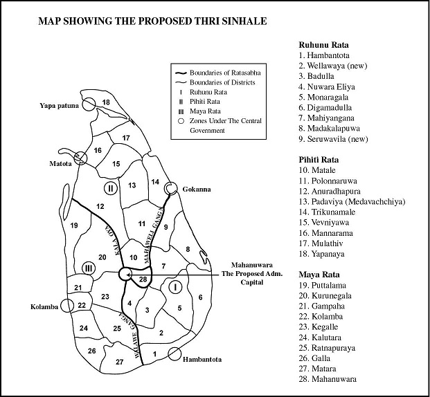
King Kawanthissa ruled the “Ruhuna” kingdom while there were two other kingdoms named “Pihiti” and “Maya”. It is said that there were only four entrances from “Ruhunu” kingdom to “Maya” Kingdom; Kadadora, Watadora, Niyangandora and Galdora. Only remaining ruins of four entrances, “Kadadora” which is also known as “Dehadukadulla” is in Kothmale area, but unfortunately we couldn’t visit that in this journey. It is said that prince “Gamunu” hid his royal sward in a tree near “Kadadora” before entering Kothmale, where now only remains a stone staircase towards Kotagapitiya starting from a (stone) entrance which has been restored. Ruins of an “Ambalama” (a hut like structure – resting place for travelers), which is beleived to be built by the prince “Gamunu” is also along the path to Kotagapitiya.
The house of “Uru pelesse Gama Mahage” of the village Kotagapitiya in Kothmale is believed to be the place where the young prince Gamunu hide after sending female jewellery to his father, as a symbol of his weakness not to starting a war with the enemy King “Elara”. Then the prefix “Dushta” (Wiked) is added upon his name “Gamunu” and shortened to be “Dutu Gamunu” afterwards. The folklore says that the prince was discovered by the Royal elephant “Kandula” after the death of king “Kawanthissa”, realizing the villagers that the boy who lived among them by the name “Guptha”, actually is the royal son. Tales say that the farmer and his family begged for their lives thinking the “King to be” may slaughter them as they used him as a helper, but instead the prince married “Ran Menika”, the daughter of the farmer who became the Queen mother of prince “Saliya” afterwards.
Folklore reveals that the Queen mother “Vihara maha Devi” arranged secret meetings in a Raja Maha Viharaya (Temple) in Kadadora area to update the Prince about war preparations with “Velusumana”, one of his ten giants. It is said that the Chief incumbent Thero of this viharaya knew the true identity of the prince. This temple is believed to be the “Kadadora Priya Bimbarama Raja Maha Viharaya” which was in Kothmale.
In 19th Century, SriLanka carried out a huge multi purpose development, 35 year – master plan called “Mahaweli project”, based on the river “Mahaweli” and allied 6 river basins. Main objectives were increasing Agricultural production with water utilization, Hydro power generation, Settlement of landless people, Flood control and providing employment opportunities. Some of the land owners in affected areas of Dam construction were resettled in near by places where some others and landless poor were resettled in identified places, called “Mahaweli Region – A” to “H”. In 1977 a new prime minister (J.R. Jayawardena) was elected and decided to accelerate the project under a separate Ministry called “Mahaweli Development” Under Minister Gamini Dissanayake.
Priliminary studies for the Kothmale project was carried in 1961, again during 1964-1968 with foreign assistance and another feasibility study during 1973 – 1976 with Indian assistance, but the project never took off. Considering all proposals from previous studies the Kothmale project was started in 1979 under the “Accelerated Mahaweli Development Project” (AMDP) with the newly established “Mahaweli Authority of Sri Lanka”. Kothamale reservoir was created by constructing a Dam (2100 feet above Mean Sea Level) between “Thispane” and “Kadadora” hills; obstructing “Kothmala Oya”, one of the main tributaries of Mahaweli river. The Kothmale reservoir spreads across 2270 ha land with 174 million cubic meters of full capacity which powers the turbines of 206MW first ever Underground Hydro Electricity Plant in SriLanka from 1985 onward.
It is said that more than 14 tea estates and 50 villages of 3050 families (more than 15000 people) were affected by the increased water level due to Dam construction. Around 1750 families were agreed to resettle in “Mahaweli Region – H” while the other 1300 families, who requested lands near to their original habitats; were settled in the 2600 acre land acquired from Tispane and Rothscild estates.
It is said that many (Couldn’t find the exact number) ancient Temples (including Kadadora Priya Bimbaramaya, Morape Bodhimalakaramaya, Morape Subhadraramaya, Hadunuwewa Medagoda Gangaramaya, Othalawe Bodhirukaramaya, Nawangama Abhinawaramaya, Tispane Sri Subhadraramaya) and Devala (including Morape Devalaya, Hadunuwewa Medagoda Paththini Devalaya) has been identified will be below the reservoir water level. The authorities decided to build a bubble shaped pagoda with 289 feet height, named “Mahaweli Maha Seya” in the right bank of the reservoir to compensate to the submerged temples which now overlook the Kothmale valley from 4150 feet above Mean Sea Level.
I have heard that this Pagoda has an inner chamber which feature some of the ruins of submerged temples where people can visit but the increasing darkness in the surrounding urged us to go back home before the giants(elephants) start their routine walks. So we headed back to our cars from the ruins of Kadadora Viharaya and came back to Kandy around 8.30 pm.
………………………………………………………………………………………………………………………………….. …………………………………………………………………………………………………………………………………..
 …………………………………………………………………………………………………………………………………..
 …………………………………………………………………………………………………………………………………..
 …………………………………………………………………………………………………………………………………..
 …………………………………………………………………………………………………………………………………..
References:
Mahavanshaya
Sunday observer 2011, march, 13
http://mahaweli.gov.lk/en/complete.html
The Accelerated Mahaweli Development Programme By Ratna S. Cooke, 1982
