Dhanigala – The Alien Mountain

MapCrew : 10

Transportation : Personal Vehicles

Duration : 1 Day


I frequently travel from Mahaoya to Dehiaththakandiya through Maduru Oya National Park for work. There is a weird looking Jurrasic park material mountain, which had a flat top on top of a wall like boulder. It is located in a small rural village called Kandegama (Meaning the village on the mountain) in Aralaganvila and named “Dhanigala” but famous as “The Alien mountain”. It is said that there are lights traveling to the mountain from the sky at night and sometimes come to the village too.
😛

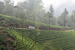
One of my friends called me on a Saturday and suggested  to visit there on the next day, and I agreed without any hesitation as I always wanted to climb that weird mountain. Our plan was to start the journey around 6 am from Kandy but things got delayed and it was around 6.30 when we started from Peradeniya. I went picked a friend on my way and another four friends had already started the journey on another vehicle. We stopped before Hunnasgiriya and had Pol Roti and plain tea for breakfast. It was around 10.30 am when we reached Mahaoya Town. The road upto Kirawana (Mahiyanganaya – Padiyathalawa border) is carpeted and in a very good condition but the remaining stretch is narrow and was in a very bad condition. It took around another half an hour to reach the temple just below the alien rock, “Dhanigala”.

…………………………………………………………………………………………………………………………………….

DSC_1124DSC_1126…………………………………………………………………………………………………………………………………….

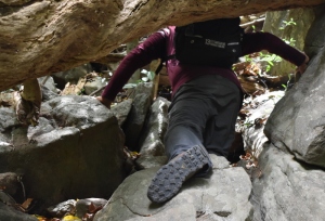
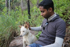
We asked the direction from a villager who was in the temple at that time and started to climb. But only after few hundred meters of climb we realized we won’t make it to the top without someone to guide. So we took a break while two of my friends went back to the temple and found a person who is willing to guide us. He was friendly but silent, who knew the mountain very well. There were ruins of a temple half way up. Thick brick walls covered a inclining Buddha statue which was damaged by the relic hunters. It was a very heartbreaking to witness the devastation done to these heritage which we should be protecting for the generations to come.

…………………………………………………………………………………………………………………………………….

DSC_1145DSC_1143…………………………………………………………………………………………………………………………………….

DSC_1140…………………………………………………………………………………………………………………………………….

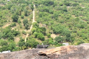
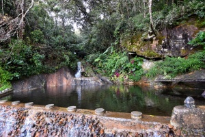
We took many water breaks as it was steaming hot even under the shades of giant tree umbrella. We reached the top without much hassle and took our time wandering around observing the unusual setting. View from the top of Dhanigala is Amazing. It was covered in tree up to the horizon other than the Aralaganvila – Mahaoya Carpet Road. We saw Maduru Oya reservoir surrounding many other small tanks which have started to dried out by the harsh weather. Few hours later, we were fed up facing the mighty sun alone and thought of descending to have the protection of tree shield.

…………………………………………………………………………………………………………………………………….

DSC_1148DSC_1157…………………………………………………………………………………………………………………………………….

DSC_1256…………………………………………………………………………………………………………………………………….

DSC_1177DSC_1197…………………………………………………………………………………………………………………………………….

DSC_1200DSC_1175…………………………………………………………………………………………………………………………………….

DSC_1219DSC_1202…………………………………………………………………………………………………………………………………….

DSC_1251…………………………………………………………………………………………………………………………………….

It was harder to descend than the climb. We were out of  water reserves and our legs were weak. Plus we didn’t pack any lunch thinking we will be able to finish the hike sooner. We climbed down to the temple around 3.00 PM and the Monks were kind enough to provide us with what is left from their “Dane” (Offerings from villagers for their lunch). It took only few minutes for us to finish it off and we started a chat with the head monk regarding the stories related to The Alien Rock. Even though we couldn’t see any proof, the villagers believe aliens are landing on top of dhanigala as they said to have seen strange lights descending from the sky and going back up. We thanked the head monk for the food and started our journey back with the mysteries of odd shaped giant rock in the wilderness.

…………………………………………………………………………………………………………………………………….

DSC_1274DSC_1299…………………………………………………………………………………………………………………………………….

We went to see the Maduru oya dam on the way back to mahaoya. When the dam was designed under accelerated Mahaweli Project and the excavations were started, they discovered an ancient sluice with dual inlets at the exact same location where the sluice was designed by the modern engineers. Therefore, the new design was changed to preserve the old sluice gates and we were lucky to witness the irrigation engineering marvel estimated to be constructed in 600 BC. We reached Mahaoya around 5pm, where I bid farewell to the hiking pals and drove towards Ampara as the next day was a Monday.

…………………………………………………………………………………………………………………………………….

DSC_1314…………………………………………………………………………………………………………………………………….

DSC_1325DSC_1329…………………………………………………………………………………………………………………………………….

DSC_1311…………………………………………………………………………………………………………………………………….

DSC_1342DSC_1349…………………………………………………………………………………………………………………………………….

DSC_1355…………………………………………………………………………………………………………………………………….

North Cove Cabana II

MapCrew: 11

Transportation: Personal Vehicles (Kandy – Castlereigh), Personal Vehicle and a Hired Van (Castlereigh – Northcove cabanas)

Duration: Two days


It was a cold weekend in December, 11 of us started the journey from Kandy heading to North Cove Cabana for the second time, which was planned couple of months back. (Read more about our first visit)

We started the drive from Kandy around 8.45 am and decided to stop for the groceries at Gampola. Drizzling which started early in the morning was almost stopped at that time and we spent one and half hours selecting groceries for just three meals! We were going by three personal vehicles, two Cars and a good old jeep. So we loaded all our backpacks to the jeep and packed the groceries in to cars.

We used Peradeniya – Gampola – Nawalapitiya – Ginigathhena – Hatton route to reach Castlereigh area. The road is too bendy and we kept our speed low as the weather conditions were not too favorable for such a road. Few of my friends wanted to purchase jerseys, so one car and the jeep took a break in Hatton. The other car was already at Castlereigh at that time. 😛
It took only around 30 minutes do the jersey shopping and we were passing Dickoya when we got a call from the friends who were at castlereigh. Since it was a poya day they were unable to find a place to order our lunch. So eight of the team decided it is better to go back to Hatton for the lunch. Three, including me were not hungry at that time and thought of roaming around while others have lunch. There is an old Chapel overlooking beautiful castlereigh reservoir and it was surrounded by a graveyard. It looked mysterious and elegant at the same time. Me and other two friends took sometime walking around the chapel and the grave yard for the perfect spots to capture a better view of the reservoir.
…………………………………………………………………………………………………………………………………….
DSC_4511…………………………………………………………………………………………………………………………………….

It took longer than expected for the team to travel back to hatton as well as to have the lunch. Finally it was around 4.30 pm when they reached the place for our cars to be parked and shift to the hired van. All backpacks and groceries were shifted to the jeep and nine of the team seated in the hired van. Two of us drove the jeep loaded with Food!

…………………………………………………………………………………………………………………………………….

DSC_4545DSC_4547…………………………………………………………………………………………………………………………………….

The van stopped at Norwood Fuel station to top up and started the climb. The road has extreme bends and narrow sections, but it is not too bad in condition. Therefore, even a car with good ground clearance would easily take you to North Cove Cabanas. Since we started the drive from castlereigh later than expected time, it was dusk when we reached the “Loinorn” tea estate. There was another 45 minutes drive as we were ascending on the 1st gear. The sun hid behind adjacent mountains as we reached the Cabanas and one of the caretakers was there with a torch to welcome and give us a hand to unload the groceries.

It was cold already and the surrounding tea plantation was covered in mist. The waterfall provided a mystique background music to our chatter. We took our backpacks to the cabanas and settled in, when the caretaker announced the most important news of the day!
They have hot water…..
It took around 1 hour for eleven of us to take showers using two bathrooms and a hot meal was waiting for us in the cottage kitchen. We ate too much appreciating the culinary skills of the caretakers. Then started the roasting sessions and we had much to talk as we met after long “trip-less” months.  It was after midnight when we went to sleep on the comfy beds. There were three triple bed cabana and one Four bed cabana, which was more than adequate for our group.

…………………………………………………………………………………………………………………………………….

DSC_4594DSC_4860…………………………………………………………………………………………………………………………………….

DSC_4734DSC_4729…………………………………………………………………………………………………………………………………….

DSC_4673DSC_4674…………………………………………………………………………………………………………………………………….

DSC_4720DSC_4739…………………………………………………………………………………………………………………………………….

DSC_4784DSC_4740…………………………………………………………………………………………………………………………………….DSC_4938DSC_4879

…………………………………………………………………………………………………………………………………….

DSC_4927…………………………………………………………………………………………………………………………………….

It was around 8 am when we woke up and a steaming hot tea was waiting for us. We had more to talk before the breakfast and had plenty of time to walk around and admire the surrounding. Sun glanced upon us for few hours and again hid behind the thick cloud cover. We took a walk down the tea plantation to take a look at the waterfall from another angle. The Cabana looked as a part of the environment, vines and bushes covered most of the walls and a wooden bridge with a roof connected the two sides of the waterfall. There was a furry friendly dog at the Cabana and he won the attention of us all.

…………………………………………………………………………………………………………………………………….

DSC_5116…………………………………………………………………………………………………………………………………….

DSC_4934DSC_4895…………………………………………………………………………………………………………………………………….

DSC_4694DSC_4697…………………………………………………………………………………………………………………………………….

DSC_4777…………………………………………………………………………………………………………………………………….

Soon a delicious lunch was ready and there was Papaya and Yogurt for dessert. The lunch was heavy and two of my friends decided to take a dip in the ice cold water to balance it out. Caretakers directed us to the man made pond above the main waterfall for safety. Some time later another few decided to join them and others (including my self) had our fun, laughing at them who were shivering in that cold water pond.

…………………………………………………………………………………………………………………………………….

DSC_4831…………………………………………………………………………………………………………………………………….

DSC_4698DSC_4699…………………………………………………………………………………………………………………………………….

DSC_4916DSC_5062…………………………………………………………………………………………………………………………………….

The van was there when my friends decided to come out of the pond. Caretakers made us a hot ginger tea and we thanked them before departing the comfy cabanas. We had more to admire about the surrounding when going back, as it was dark and we didn’t see much when traveling up. Every hill top is covered by lush green tea bushes and it was mesmerizing. We arrived at castlereigh around 5.30 pm and got back in to the vehicles that we came from Kandy. The caretakers at North cove had packed us some sandwiches and we had it before starting the drive back to Kandy. We drove really slow as the drizzle over the darkness blurred the bendy road. It was around 9pm when we reached Peradeniya and departed with hopes for another adventure in near future.

…………………………………………………………………………………………………………………………………….DSC_5148

…………………………………………………………………………………………………………………………………….

DSC_5127DSC_5140…………………………………………………………………………………………………………………………………….

DSC_5130DSC_5145…………………………………………………………………………………………………………………………………….

DSC_5129…………………………………………………………………………………………………………………………………….

Maldives – What to Know Before Traveling

DSC_2333

Maldives is a collection of thousands of small Islands identified as 26 atolls. It has around 298 square kilometers which provide homes to around 450,000 people. It is identified as the world lowest country with average 1.5m above sea level. Here are some important facts for the first time travelers to this Island Nation, Maldives.

……………………………………………………………………………………………………………………………………..

Visa

Maldives offers On-arrival visa  for all nationalities. You can check further details from following link. Entry to Maldives.

……………………………………………………………………………………………………………………………………..

Weather

Maldives generally has a constant warm weather along the year but the northeast monsoon affects from May to October creating a wet season and making the November to April dry season a famous holiday attraction.

……………………………………………………………………………………………………………………………………..DSC_2398

……………………………………………………………………………………………………………………………………..

Transport

Main transport method of Maldives is boats as it is the most feasible and cheapest option. They are called “Dhoni”s and normally they are used to travel in between residential islands. But there are few Resort Islands which has facilities to accommodate domestic flights, which is the most expensive transport option. If you are in a hurry, but little light on budget there are speed boats to be rented for a price in between. Most hotels provide airport pickup and drop services using speed boats free of charge.

……………………………………………………………………………………………………………………………………..

DSC_2436

……………………………………………………………………………………………………………………………………..

DSC_2456

……………………………………………………………………………………………………………………………………..

Communication

Almost every resort Islands to budget hotel provides free wifi. There are two service providers called “Dhiraagu” and “Wataniya”. Since the islands are small, you can survive with hotel wifi. But if you are planning to visit Male town or Hulumale, it is better to activate roaming or buy a sim from local service provider.

……………………………………………………………………………………………………………………………………..

Culture

At Present Male is an Islamic country and there language “Dhivehi” is somewhat similar to “Sinhala” (Used in Sri Lanka). Maldivian culture is bit conservative, but women play major roles unlike in other Islamic countries.

Drugs and Liqueur are prohibited in residential islands. Also there are certain limitations to beach wear in residential areas. But they have adapted well to tourism, which is their main income; making liqueur available in resort islands and cruise ship floating restaurants. Also there are public beaches in residential Islands which allows bikinis like swim wear.

Generally the Maldivians are friendly and fluent in English. Other than tourism, fishing related exports play a major role in their economy.

……………………………………………………………………………………………………………………………………..

Food

As this is an Iisland nation, fish is the most common food item. They are famous for Canned fish and “Maldive fish (Umbalakada)”. Other dishes are somewhat related to the cuisines of surrounding countries. Most western food items are available in all restaurants.

……………………………………………………………………………………………………………………………………..

DSC_2296

……………………………………………………………………………………………………………………………………..

“Do”s and “Don’t”s

  1. There are many items prohibited in Maldives, Therefore make sure you check this list beforehand. (Note that Pork is considered a banned item as this is a Muslim country)
  2. Do not engage with marine life (Fish or Corals) while snorkeling or Diving.
  3. Dress modestly when visiting residential islands and non – bikini beaches, Take off footwear before entering a home or a religious place.
  4. Do visit Local Markets in Male, There are lots of fresh produce for cheap prices.
  5. Change your USD at the airport or in the hotel (If the service is provided) to local currency if you are planning to visit residential islands like male or hulumale. You can use USD for purchase items, but the exchange rates used by the vendors will be very disadvantageous.

……………………………………………………………………………………………………………………………………..

Must Do Activities

  1. Snorkeling
  2. Para Sailing
  3. A Sand Bank Visit
  4. A resort Island Visit
  5. Visit to the Local Markets in Male

……………………………………………………………………………………………………………………………………..

DSC_2446

……………………………………………………………………………………………………………………………………..DSC_2101-001

……………………………………………………………………………………………………………………………………..DCIM100GOPROGOPR0399.

……………………………………………………………………………………………………………………………………..

DCIM100GOPROGOPR0455.

……………………………………………………………………………………………………………………………………..

Makare

MapCrew : 8

Transportation : Double Cabs

Duration : 2 Days


Visiting the famous “Makare – මකරේ” or the “Dragon Mouth” was in my mind for a long time but couldn’t find a time and a gang to visit there. Suddenly the idea of camping in the “Gal Oya” national park was suggested by my friend and luckily, there were many friends looking to join for the trip. We fixed a date on a weekend and reserved the Wild Life Department Nilgala Circuit Bungalow two weeks Prior. (Click here to Reserve Bungalows Operated by Department of Wild Life Conservation, Sri Lanka)

Seven of us departed Inginiyagala around 1.30 pm in two vehicles and pick another friend at the turning point for Nilgala Wild Life Department bungalow on Inginiyagala – Bliba Road. Access road is more of a dirt path with bushes creeping in, where we saw few households up to the border of the Galoya Forest Reserve. We reached there and settled in Nilgala wildlife bungalow around 4 pm and prepared for the BBQ. The staff supported us to marinate the chicken (There are no super markets or even large scale boutiques nearer, so better to bring all supplies from the nearest town. We bought our supplies from Ampara). The hardest part was to light up the charcoal in the BBQ grill which we brought with us.
…………………………………………………………………………………………………………………………………….

DSC02366DSC02374…………………………………………………………………………………………………………………………………….

DSC02368…………………………………………………………………………………………………………………………………….

DSC02373DSC02370…………………………………………………………………………………………………………………………………….

DSC02372DSC02382…………………………………………………………………………………………………………………………………….

DSC02384…………………………………………………………………………………………………………………………………….
Then we went for a bath in the Gal Oya, which is few meters away from the place where we stayed. The environment was clam and warm, urging us to take a dip in the cold water. The water flow looked slow, but was strong and deep in some sections. The caretakers made us a delicious dinner to enjoy with the BBQ and we enjoyed it before going to sleep a bit  late.
…………………………………………………………………………………………………………………………………….

DSC02383DSC02387…………………………………………………………………………………………………………………………………….

DSC02399…………………………………………………………………………………………………………………………………….

DSC02397DSC02403…………………………………………………………………………………………………………………………………….

DSC02411

DSC02408

…………………………………………………………………………………………………………………………………….

DSC02415…………………………………………………………………………………………………………………………………….
We woke up in the morning and our plan was to visit Makare and do a small hike on a wild trail. So we decided to visit makare before the breakfast and started our journey for the day. The road was not that difficult but it is recommended to use a vehicle with a good ground clearance, Four wheel drive is not a must. It took us a considerable time to drive up to makare as we were going below 10kmph all the time. After reaching a small hill like dead-end, we had to walk down to Gal oya. We took some time to capture the beauty of the stream running over the rocky surface. There were signs of a very high water level marked on nearby cliffs which was around 10-15 ft higher than the water level at that time.

Our guide took us on a footpath along the left bank of Gal oya and reached the famous “Makare” after few minutes walk. I imagined that it is a one giant rock and the water is flowing under it. But actually it is a collection of countless big rocks and the water is flowing through that rock filter. So we can’t see water flow unless Gal Oya is over flowing (Which is a seasonal thing if the top end of Gal Oya gets enough rain).
…………………………………………………………………………………………………………………………………….

DSC02429DSC02434…………………………………………………………………………………………………………………………………….

DSC02437-001DSC02441…………………………………………………………………………………………………………………………………….

DSC02442DSC02451…………………………………………………………………………………………………………………………………….

DSC02448…………………………………………………………………………………………………………………………………….

DSC02472…………………………………………………………………………………………………………………………………….
After clicking few photos there, we decided to head back to our vehicles and go to one of the nearest campsites. We brought a small tent hoping to use it in case we needed, but it wasn’t. So we used it as a backdrop for some group photos!
😀
We were really hungry and missing the breakfast at that time, so we decided to cancel the hike we planned and return to the wildlife bungalow as soon as possible. It took around another 45 minutes drive for us to reach there, and a delicious breakfast was on the table as we arrived.

Since we didn’t had much time to plan and due to the last minutes participation, the food we brought finished with that breakfast. So we decided to head back to Mahaoya for Lunch and to have another dip in the nearby section of Gal Oya before the return trip.
…………………………………………………………………………………………………………………………………….

DSC02475DSC02488…………………………………………………………………………………………………………………………………….

DSC02491DSC02494…………………………………………………………………………………………………………………………………….DSC02496DSC02499…………………………………………………………………………………………………………………………………….
On the way we saw some fresh elephant dung, indicating that there was at least one elephant nearby. It made us cautious and one of us spotted a small foot prints running towards the stream!
We heard a noise amid the discussion to guess who owns those foot prints. A wild boar appeared out of nowhere and it was coming towards us. Our immediate thoughts were to run for our lives, but we didn’t except making room for the boar to pass the group of us. The boar wasn’t a fully grown one and neither of us could see the Incisors that we were heard of. The boar decided to come towards us anyway and the time seemed passing in slow motion. The boar stopped near a puddle and rolled over resting up side down like a dog. It made us bit relieved and I tried to click some photos.

After having a minute of mud bath the bar again started following us. Then we realized that it must be used to humans and looking for something to eat in the bags we were carrying our towels and stuff. No one had anything to offer to the boar, but he followed us to the stream anyway.
…………………………………………………………………………………………………………………………………….DSC02506DSC02581…………………………………………………………………………………………………………………………………….

DSC02518DSC02513

…………………………………………………………………………………………………………………………………….
We jumped from the bank on to the rocks coming out of the stream and started to walk toward the usual spot we bathed the day before. We though then the boar will get back to the jungle as he can’t follow us. But we were wrong and the boar tried to test its swimming skills! But the water flow was high and it seemed that the boar is drowning. We were hopeless and the only thing we could do is to run towards a shallow bank and call it to swim there. After few minutes of rigorous swimming the boar made it to the bank we were on. It was tired from the fight with the mighty currents of Gal oya and let us even pet it.
😛

After a while a dog who lives in the Nilgala wild life bungalow came to the stream and the boar disappeared in to the jungle. So we too went on to have a bath and spent a quality time dipped in cold water. Afterwards it took only few minutes for us to pack our things and start the journey back. We went to Bibila town for the lunch and dropped one of our friends there. Drive back to Ampara took around another two hours and we finished the journey around 5 pm with a whole lot of unforgettable memories.
…………………………………………………………………………………………………………………………………….…………………………………………………………………………………………………………………………………….DSC02525DSC02531…………………………………………………………………………………………………………………………………….DSC02544DSC02555…………………………………………………………………………………………………………………………………….IMG-78b297589312277801d65de5c1dec1bc-V…………………………………………………………………………………………………………………………………….

Nalanda Gedige

Map
Crew : 5

Transportation : Car

Duration : 1-2 Hours

It was a sunny Saturday and I were driving on A9 from Habarana to Kandy with my Family. On the way around Naula, I remembered that one of my friends had posted a photo of Nalanda Gedige, which is located somewhere nearer. All in the car agreed to take a break and visit Nalanda Gedige. So my brother turned on GPS in his mobile and guided to the destination.

The by road was in good condition and it is easy to find the place even without GPS. There is a fairly large area under the shade of trees for vehicle park. There was a security hut and an information center, but couldn’t find anyone to inquire about the entrance ticket. After a few minutes of search we found a notice that this attraction has No Entrance Fee!
😀
…………………………………………………………………………………………………………………………………….
DSC01684…………………………………………………………………………………………………………………………………….
DSC01624DSC01625…………………………………………………………………………………………………………………………………….
So we walked under a stone gate frame to enter a long shady path with carved boulder borders. There is a sign post at the end of the path. The original location of this structure was somewhere else and they had to relocate it due to the construction of Bowathenna reservoir under Mahaweli Development Project.
…………………………………………………………………………………………………………………………………….
DSC01626DSC01681…………………………………………………………………………………………………………………………………….
DSC01680DSC01678…………………………………………………………………………………………………………………………………….
DSC01677…………………………………………………………………………………………………………………………………….
DSC01673DSC01668…………………………………………………………………………………………………………………………………….
This was build between 8-10 AC with “Pallawa” architectural features. It believed that the original location of Nalanda Gedige is the Geographically central point of Sri Lanka.
…………………………………………………………………………………………………………………………………….DSC01661
DSC01653…………………………………………………………………………………………………………………………………….DSC01675
DSC01655…………………………………………………………………………………………………………………………………….
DSC01660…………………………………………………………………………………………………………………………………….
DSC01652…………………………………………………………………………………………………………………………………….DSC01663DSC01665
…………………………………………………………………………………………………………………………………….DSC01648
DSC01666…………………………………………………………………………………………………………………………………….
There are three main parts, A pagoda (Dagaba), A bo Tree and a Kovil like structure as a Viharageya which is named as “Gedi ge”. It is a stone made building with a half cylindrical stone roof surrounded by a covered hall with stone pillars supporting a(should be wooden) roof. Only one staircase of entrance with “Korawakgal” for railings and plain “Sandakada pahana”.
…………………………………………………………………………………………………………………………………….
DSC01646DSC01636-001…………………………………………………………………………………………………………………………………….
DSC01634…………………………………………………………………………………………………………………………………….DSC01630
DSC01628
…………………………………………………………………………………………………………………………………….
I were amazed by the creativity and skillfulness of the craftsmen as well as the people who relocated such a complicated structure. There were three statues and a guard stone inside Gedige, One statue of a god and Two statues of lord Buddha where one was missing the upper part. We spent another half an hour admiring the surrounding and started our journey back to Kandy.

Arugam Bay

MapCrew : 7

Transportation : Cars (Kandy > Mahiyanganaya > Ampara > Akkaraipattu > Pottuvil > Arugam Bay > Pottuvil > Lahugala > Siyambalanduwa > Wadinagala > Ampara > Inginiyagala > Bibila > Mahiyanganaya > Kandy)

Duration : Two Days

I had plans to visit Arugam bay beach and spend a night there during the surfing season (May to September), But it kept postponing. There was a free weekend coming and seven of my friends confirmed participation. This time our plan was to spend more time on the beach as possible, So I wanted to reserve a place closer to the beach unlike in our previous visit (Read about our visit to Arugambay and Kudumbigala).

The gathering point was Kandy as most of my friends were there. One came from Kurunegala and another one all the way from Colombo. I was already in Ampara and planned to join them from there onward.  It was around 6.15 am when others left Kandy and they took around 4.5 hours to reach Ampara Via Padiyathalawa. As soon as they arrived Ampara we had a quick breakfast and started our drive to Arugam bay via Akkaraipattu. There was almost no traffic, so we reached Arugam bay just around an hour. We directly went to the hotel we reserved. It took another half an hour for us to settle in, before starting our search for a good place to have the lunch. The staff at our hotel recommended a place (Ranga’s Beach Hut) which reminded us that we have been there in our previous visit. It was just a couple hundred meters away next to the beach and we decided to walk up there by the main road. Even though it is off season, there were few groups of travelers in the restaurant area. We asked for their famous “Rice and Curry with Fried Fish” but sadly it was finished by that time. So we ordered Fried rice and soft drinks after settling to a table under a shady tree. Environment was way cooler than the outside road because of the giant umbrella of trees branches. They took some time to prepare the food but we didn’t noticed that as we were busy with catching up and admiring the surrounding.
…………………………………………………………………………………………………………………………………….
22730249_10212747502459635_9045449545670765253_n22712308_10212747500219579_2597253512175104978_o…………………………………………………………………………………………………………………………………….
DSCF6272…………………………………………………………………………………………………………………………………….
DSCF6263DSCF6282…………………………………………………………………………………………………………………………………….
We spent a more than an hour there and decided to walk back to the hotel through the beach. It was easier than walking on the main road plus we had a perfect view of Arugam bay. My friends were sleepy as they started the journey in the early morning and decided to take a quick nap until the burning sun rays fade away. But no one could sleep but talk lying in beds and chairs!
😀

We took a shower first to cool off and then decided to walk to the beach around 3.30pm. Even though our hotel was next to the beach, famous Arugam bay surfing spot was another one kilometer away. We saw many places that was threatened by sea erosion (may be a seasonal thing due to the changing tide patterns). There were quite a lot of people on the surfing spot, but only a few were surfing. We walked further to avoid the crowd and spent hours lying on the beach. The tides were so strong that sometimes it dragged us along the beach for couple of feet reminding our younger days! We didn’t wanted to worry about getting our cameras wet, so couldn’t capture any photo during our “floating in the beach” session. It was around 6pm when we decided to head back to our hotel. The sun just sank behind the coconut trees within couple of minutes, making us to walk back under the dark starless sky. Lights from the hotels marked the beach, up until the Arugam bay bridge. It took us more time than we expected to walk back to the hotel and had to spend another hour or so washing away the sand from our clothes and hair.

We decided to go for another cafe for dinner just for a change and looked up for few restaurants with good reviews on the internet. There was a Pizza place and we walked along the main road towards panama side. After about a 700m walk we reached to a cozy looking place and decided to settle down there as we were bit tired of walking to the place we initially planned to go. Gladly they too had wood oven pizzas and took some time to prepare it.
…………………………………………………………………………………………………………………………………….
DSCF6284…………………………………………………………………………………………………………………………………….
DSCF6298DSCF6291…………………………………………………………………………………………………………………………………….
One story lead to another and suddenly realized that we were the only group left in the restaurant and it was almost their closing time. So we left there and walked back, admiring the atmosphere created by dim lights of the nearby boutique hotels. We all were so tired and just went to sleep as soon as we came back to the hotel.

It was around 7 am when I woke up in the next morning. Sun was already up and making the morning tides shine. There were two hammocks fixed in the hut on beach, and i decided to hop on. It was my first experience about hammocks and it was better than i imagined. Everything was so calm and peaceful that I even noted pros and cons of living next to a beach in my mind. We decided to go to the same place that we had the previous day lunch for the breakfast. It was much closer through the beach, so we walked there. It was one of the best satisfying breakfasts that I have ever had. Tasty eggs with crunchy toasts and a hot cup of tea under the shade of a tree along with the company of good friends; that was perfect!
…………………………………………………………………………………………………………………………………….

DSCF6309DSCF6311…………………………………………………………………………………………………………………………………….

DSCF6320DSCF6313…………………………………………………………………………………………………………………………………….

DSCF6330…………………………………………………………………………………………………………………………………….

After spending more than an hour on the breakfast we walked back and stepped in to the sea from the beach just next to our hotel. Some waves were higher than us, which tried to throw us back to the beach. We didn’t realize the time passing and it was almost 1 pm when we came out of water. It was time for us to pack our bags and check out from the hotel. Few friends wanted to buy souvenirs and there was a shop closer to hotel on the main road.
…………………………………………………………………………………………………………………………………….

DSCF6327DSCF6328…………………………………………………………………………………………………………………………………….

DSC_806822730250_2013397438673819_1982244821709289222_n…………………………………………………………………………………………………………………………………….

Breakfast made a really good impression on us that we went to the Ranga’s Beach Hut for the third time to have Rice and curry for the Lunch. They had a tasty fried fish dish, which we ordered extra just because it tasted better. It was few minutes passed 3pm when we bid farewell to Arugambay and started our drive back to Ampara through Siyambalanduwa. There was a herd of Elephants near the Lahugala tank, so that we took  a break to add some photos to the memories. We all reached Ampara around 5 pm and my friends went towards Kandy after having a good cup of good bye tea.

…………………………………………………………………………………………………………………………………….DSCF6338DSCF6341…………………………………………………………………………………………………………………………………….DSCF6351DSCF6345…………………………………………………………………………………………………………………………………….

DSCF6355…………………………………………………………………………………………………………………………………….


Ella Rock

Map

Crew : 6

Transportation : Cars (Kandy to Ella and back), Walk (Ella Rock)

Duration : Two Days


There was a long weekend coming and one of my friends suggested to go on a road trip. Though we had many suggestions earlier for road trips, all were limited to planing stage. So we decided it is better to plan a small road trip with more time allocated to sightseeing than driving. “Ella” won most of our votes. There were only six people confirmed participation (Including me) and two cars were more than enough. To make that more of a road trip, we decided to go to Nuwara Eliya on the first day and then drive to Ella and spend the night there. Our initial plan was to camp at Ella rock but we found out that it is not allowed to camp there now as someone has set fire (may be mistakenly but it is totally irresponsible) in recent past. We were angry with the people who are responsible to the fire for ruining a another best camping location for Sri Lankans. So we had to search for accommodation and found a decent place in Ella town for reasonable price.

We spend the night of the previous day at a friend’s house. We started our drive around 9 am from Pilimathalawa by two cars. We had breakfast in Gampola town and took our time driving up to the misty hills of Nuwaraeliya. All four of the usual partners for bicycle rides (Read more about our bicycle rides from Nuwara Eliya to Kandy and Pattipola to Kandy) were there, so we took a break to have a good cup of tea at our favorite spot. A hot cup of tea combined with a piece of chocolate cake from Macwoods Labukellie tea Centre was the ideal combination for the misty and cold weather. It took around another half an hour to take a group photo and hang around the observation deck.
…………………………………………………………………………………………………………………………………….18491685_1758641527486045_694067606873923044_o
…………………………………………………………………………………………………………………………………….
18489679_1758639047486293_7783345629866926412_o18517996_1758638347486363_6246576930089623428_o

…………………………………………………………………………………………………………………………………….18518342_1758640024152862_7690496756726733918_o…………………………………………………………………………………………………………………………………….
Next we drove up to NuwaraEliya town. It was just around noon and we were not hungry. So we went to the park next to the Lake Gregory and enjoyed the warm sun rays filtering through the misty clouds. It was a long weekend and the park was fairly crowded. Children were in line to take a ride on a Pony while a bit older crowd were focusing on a Zip line across the park. After spending sometime lying on the ground we thought of checking out the kayaks that were for rent. It was 500 LKR per kayak for 45 minutes. We rented three kayaks and teamed up to balance the weight! 😀 We had to be seated when they pushed the kayaks to water from a feet height lake bank. We were bit worried about the balance and splash of water, but they managed to put our kayaks to water safely.
…………………………………………………………………………………………………………………………………….18558741_1758761110807420_127088797361000753_o18527112_1758640894152775_7019476613349627924_o
…………………………………………………………………………………………………………………………………….18527169_1758640020819529_5865554796385935020_o…………………………………………………………………………………………………………………………………….18556440_1758642284152636_8281952112759130978_o18451474_1758760880807443_538746128270620434_o
…………………………………………………………………………………………………………………………………….18518234_1758644637485734_2335284843804842902_o
…………………………………………………………………………………………………………………………………….18556687_1758644164152448_5806078539292477615_o18527504_1758631427487055_3709989596673470700_o
…………………………………………………………………………………………………………………………………….
It was easier than it looked. We got used to the kayaks and rowed them to the other corner of Lake Gregory. We were busy with taking photographs and suddenly realized that the lake surface is empty and we were the only people in the middle of the water. Then a sharp whistling noise pointed us to the sky. A seaplane was about to land on us!!!
😛
So we used the full strength and rowed our kayaks to the closest river bank. The plane landed afterwards giving us better opportunities to take more photos. We decided to head back to the land to have the lunch. We searched for restaurant suggestions in the internet  and went straight to “Salmiya” restaurent but they had many orders waiting so we decided to look for something else as we were extremely hungry. Our next stop was “Calamander Lake Gregory”. We ordered soon and enjoyed our food for more than an hour before starting the journey up to Ella.
…………………………………………………………………………………………………………………………………….18451775_1758640394152825_3661809312086989107_o…………………………………………………………………………………………………………………………………….
18449650_1758631844153680_4288113424693545031_o…………………………………………………………………………………………………………………………………….18449514_1758634700820061_6663152876509696916_o…………………………………………………………………………………………………………………………………….18451361_1758632117486986_235642860613573569_o…………………………………………………………………………………………………………………………………….
We reached Ella around 5 pm and took some time to rest after the long drive. It was drizzling and the whole world was covered in freezing cold mist when we looked outside. We had no choice but to go out for Dinner. We went straight to Cafe Chill as we were there before and it was popular for their tasty dishes. It was 30th of December and they had a DJ organized. So we thought to go there and asked the staff about it. Sadly the waiter informed that they have limited it only for foreigners due to some issues occurred sometime before. It was a big slap for Locals but we had to accept the fact that the owners made the decision in favor of their industry and the good name of Sri Lanka. So we went straight back to the place we booked and went to bed early with the hopes of starting the Ella rock Journey early in the morning.
…………………………………………………………………………………………………………………………………….18491762_1758760684140796_7281902673391038282_o…………………………………………………………………………………………………………………………………….18489578_1758760640807467_1820897480912140753_o18451378_1758760927474105_6153979177668261083_o…………………………………………………………………………………………………………………………………….
It was around 4 am when i woke up by the alarm. We hurried in to our hiking clothes and went toward the Ella rock road by a car. We were said that the by road to Ella rock is on the left hand, so we decided to use google maps to find the location. It took only 30 minutes to reach the google map location but we couldn’t find any junction. So we decided to seek help from a villager. But we couldn’t find anyone as it was too early. Then a Threwheeler came towards us and we asked them about the directions. They directed us towards a junction on the road we came and when we went, there wasn’t any by road. So we searched on our own for around 30 minutes and found out that the people who we asked for directions had mislead us, The by road was just few meters ahead of the place where we met them! That was one of the worst experiences I have ever had.

We drove on that road and came to a dead end near the Kithal-Ella Railway station. The final part of the road is not in a good condition but our car managed to do some Off road-ing. We parked it near by and went down on a foot path to the railway station. There was a villager feeding his cow nearby and he kindly lead us towards the trail to Ella rock.
…………………………………………………………………………………………………………………………………….IMG_4373IMG_4375
…………………………………………………………………………………………………………………………………….IMG_4376IMG_4377
…………………………………………………………………………………………………………………………………….

You have to walk on the rail track for few meters from Kithal-Ella railway station until the 166.25 sign post and take a left turn to the foot steps towards the small tea plantation. Few steps after we found a a small bridge over a crystal clear water stream but sadly the Sun came out at the exact same time. We had high hopes to capture the rising sun from Ella rock, as we heard that is a marvelous experience. But with the delay to finding the correct by road, we missed that. There was a small shop (like thing) adjacent to a clay (wattle and daub) house. We decided to have a break there as we are already late. There were biscuits so we bought a packet and had some plain tea. She was looking after three small kids (her grand children) while their parents are working somewhere, Faces of those kids gave us a clear idea about the hardship of life that they are facing. Old lady confirmed our trail is correct and gave us some tips stay on the main trail without wandering to one of many foot paths there. There was few dogs and one decided to climb the rock with us.
…………………………………………………………………………………………………………………………………….IMG_4380IMG_4382
…………………………………………………………………………………………………………………………………….IMG_4390IMG_4398
…………………………………………………………………………………………………………………………………….IMG_4399
…………………………………………………………………………………………………………………………………….

The climb was less intense for most of the part and we met few groups of foreigners on the way. Gigantic umbrella of trees filtered the warm sun rays and unveiled the beautiful sky from time to time. It was a wonderful experience and we could imagine how it will be at the sun rise. After about 45 minutes of climbing we reached to a plane, Which could have been an excellent camping location.
…………………………………………………………………………………………………………………………………….IMG_4402
…………………………………………………………………………………………………………………………………….IMG_4420IMG_4417
…………………………………………………………………………………………………………………………………….IMG_4429IMG_4428
…………………………………………………………………………………………………………………………………….IMG_4447IMG_4443
…………………………………………………………………………………………………………………………………….IMG_4453…………………………………………………………………………………………………………………………………….
Just after that the climb began, it isn’t the hardest but comparatively the way up to that point is much easier. We took many breaks to catch our breath and capture many photos as we could. We met a couple and few groups of foreigners each after a dog guiding them to the top!
😀

There are two path from the top, one towards Rawana Ella and the other just leading to the Ella town side. We spent around an hour there under the thick shade of the pine trees before starting the journey back to Ella town.
…………………………………………………………………………………………………………………………………….IMG_4477IMG_4450
…………………………………………………………………………………………………………………………………….IMG_4458IMG_4484
…………………………………………………………………………………………………………………………………….IMG_4526
…………………………………………………………………………………………………………………………………….IMG_4550IMG_4585
…………………………………………………………………………………………………………………………………….
We went straight back to the place we spend the night and packed the bags. Then went to the same cafe we had the dinner last night and had a long satisfying lunch. It was around 2 pm when we finished and decided to drive back home. We reached Mahiyanganaya around 5pm and I had left to Ampara for work while others going to Kandy.

Singapore Zoo, River Safari and Night Safari

MapCrew : 3

Transportation : MRT, Taxi

Duration : One Day


It was around 1.30pm when we left the Jurong Bird Park. (Read about my visit to Jurong Bird Park). We took a taxi to the Singapore Zoo which we felt the quickest way to reach there. As you may know, there are three adjacent parks called Singapore Zoo, River Safari and Night Safari. All three parks were designed in a way that visitors can cover the entire park by foot, but they include a tram ride or a boat ride to boost the attractiveness. The ride may cover all the important parts with a quick glance through the animals, but it may not cover the entire park. So we decided to walk around the Singapore zoo without using their tram ride, then walk around the river safari exhibits before going on the boat ride and only go on the tram ride in Night Safari so that we could go back to our hotel before midnight.

Each having many varieties of species related to there themes. We started with Singapore zoo. It felt bit “not much” organized as the Jurong Bird park, but definitely one of the well planned zoos. We took a copy of the Singapore Zoo map and started to cover the exhibits clockwise. There were a group of Otters in the begging. They were cuddling with each other to find the perfect position for a nap!
…………………………………………………………………………………………………………………………………….DSC_6591DSC_6589

…………………………………………………………………………………………………………………………………….DSC_6594…………………………………………………………………………………………………………………………………….

Then we met Malayan Tapir, Siamang, Babirusa and Pygmy Hippo. Highlight of that section was the White tiger. They were resting in the far most corner of the cubicle.

…………………………………………………………………………………………………………………………………….
DSC_6516DSC_6527…………………………………………………………………………………………………………………………………….DSC_6546DSC_6582

…………………………………………………………………………………………………………………………………….
DSC_6573DSC_6568…………………………………………………………………………………………………………………………………….
Suddenly we remembered that there was a show in the park map called “Rain forest Fights back” at 2.30pm. SO we ruched to the location though it was already 2.45pm. The venue was almost full, but we managed to squeeze in to a less crowded row of seats. The show included a large yellow Python, White peafowl and many other small animals. They always highlighted there natural behaviors with what they did in the show. Then we went to the “Primate Kingdom” and “Wild Africa”. Though we almost covered every animal in the zoo, we had to rush through certain parts so that we don’t miss the river safari.
…………………………………………………………………………………………………………………………………….
DSC_6619DSC_6682…………………………………………………………………………………………………………………………………….
DSC_6642DSC_6644…………………………………………………………………………………………………………………………………….DSC_6691…………………………………………………………………………………………………………………………………….
DSC_6659DSC_6668…………………………………………………………………………………………………………………………………….
DSC_6664DSC_6672…………………………………………………………………………………………………………………………………….

DSC_6694…………………………………………………………………………………………………………………………………….

It was around 4.15pm when we finished, and rushed to the River Safari area as there was a notice saying the boat rides will be closed after 5.30pm (Map of the River Safari). We had to walk through many exhibits to reach the Boat Safari area. They have created specific environmental conditions replicating major river of the world.  Just after the exhibit “River Wonders”, they have created “Mississippi River”, Then “Congo River, “Nile River”, “Ganga River”, “Mary River” and “Mekong River”.
…………………………………………………………………………………………………………………………………….
DSC_6705…………………………………………………………………………………………………………………………………….
DCIM100GOPROGOPR1636.JPGDCIM100GOPROGOPR1645.JPG…………………………………………………………………………………………………………………………………….DSC_6704DCIM100GOPROGOPR1628.JPG
…………………………………………………………………………………………………………………………………….
DSC_6713…………………………………………………………………………………………………………………………………….
DSC_6714DSC_6715…………………………………………………………………………………………………………………………………….
DSC_6719DSC_6711…………………………………………………………………………………………………………………………………….
Then we reached to one of the most popular section of the park, the home pf Pandas. There were few Red Pandas and Two Giant Pandas nibbling bamboo. There weren’t much crowd at that moment so we were able to leisurely take a good look at them.
…………………………………………………………………………………………………………………………………….
DSC_6732…………………………………………………………………………………………………………………………………….
DSC_6729DSC_6730…………………………………………………………………………………………………………………………………….

Then we hurried to the River Safari Cruise, Boat Dock to find out that they have started the final safari of the day few minutes before. It was 4.45pm but they said they have closed the section. It was a big disappointment for me as we could have skip the walking part and start the boat cruse first, If we knew they are closing early. We then walked out of that section with disappointment. The Amazon river Quest Boat Ride was closed too, but we could see animals from the walking path. Finally we reached the “Amazon Flooded Forest” which is a close to nature home for many native species of Fish and Amphibians. “Giant River Otter”, “Freshwater Stingray” and “Electric eel” were the highlights. The multi storied exhibit with “Manatees” and “Arapaimas” caught the eye of many visitors. We spent about a half an hour there and walked in to the “Night Safari” location around 6.30pm.
…………………………………………………………………………………………………………………………………….DCIM100GOPROGOPR1640.JPG
DSC_6735…………………………………………………………………………………………………………………………………….DCIM100GOPROGOPR1791.JPG
DCIM100GOPROGOPR1695.JPG…………………………………………………………………………………………………………………………………….DSC_6739
DSC_6745…………………………………………………………………………………………………………………………………….

We bought tickets specifically for the 7.30pm (the earliest) Night Safari Tram ride when we were purchasing in the morning. There was a lengthy queue even for that 7.30 pm ride. We quickly went through the Night Safari Map, but decided only to go on the Tram ride as we had to work on the next day morning. While we were waiting, few performers came on to a stage nearby and started a fire show. It was magnificent, seeing people dance with fire and at last eating it! We only had to wait for around 15 minutes after the fire show. We were directed towards a Tram with four seats in a row. Felt bit crowded at the first, but the feeling faded away as the tram started to move. Sadly, my fixed focus lens wasn’t enough to capture the animals in a distance at dark background. We could see them perfectly with the naked eye, so I turned off my camera. There were a lot of animals in four main sections. “Fishing Cat Trail”, “Leopard Trail”, “East Lodge Trail and “Wallaby Trail” are the fur route covered by the Tram Ride. We saw an Ice Cream shop in the main entrance after the ride and decided to taste. I had received 10 SGD discount from Uber Singapore, so we used an Uber Cab back to “Broadway Hotel” in Little India around 10pm.
…………………………………………………………………………………………………………………………………….
DSC_6753DSC_6758…………………………………………………………………………………………………………………………………….
DSC_6759DSC_6761…………………………………………………………………………………………………………………………………….DSC06547
…………………………………………………………………………………………………………………………………….

Jurong Bird Park

MapCrew : 3

Transportation : MRT, Taxi

Duration : One Day


When I got to know I have to travel to Singapore for an official matter, I did a quick search to know what to see and what to do there. Many blogs and previous travelers recommended the Singapore Zoo among the top 5 places to visit in Singapore. But the problem was time. As many said it will take more than 3 hours to cover the zoo and another 5 hours or so for the River Safari and Night Safari, I had to find a full day during the stay. Luckily there was a weekend,  which Saturday was already allocated for a group visit to Universal World, But Sunday was free.

Many had visited Singapore before in our group, so they have seen the zoo. Hence I decided to go alone initially, but found two friends interested in joining the trip. My idea was to get the maximum out of the full day, so I boldly decided to go for all four attractions “Jurong Bird Park”, “Singapore Zoo”, “River Safari” and the “Night Safari”. We took the North East Line MRT from “Little India Station” to “Outram Park” and East West Line MRT from there to “Boonlay” Interchange. Then we asked from an information counter about the directions to get a bus, The kind lady there reminded us that we will be needing the exact amount of change in cash in order to use the bus without the prepaid travel card. There was 194 Bus which goes directly to the Jurong Bird Park just outside the MRT Station, and we were able to collect required amount in coins for the bus ticket! 😀

When I searched online for information about these park, zoo and safaris, found out that all parks are planned in a way that you have to walk the full circle to cover the entire attraction but all of them have a tram ride or a boat ride to get a quick glance at them within short amount of time. As I wanted to see them all, I decided not to use the tram rides in Jurong Bird Park and Singapore Zoo.

We arrived at the Park around 9.30 am and hurried in to the ticket counters as it was starting to getting crowded. We brought Tickets for the all four parks (There was a big discount if you are buying tickets to the all four parks at once, Tickets are Valid within a week of the date of purchase) for 69 SGD per person. We took a minute to see the Jurong Bird Park Map and started from the Penguin Coast. A group of penguins were swimming and playing in an open pool near a model of a large ship. I found out that they are a special species of Penguins that live in a bit warm weather.
…………………………………………………………………………………………………………………………………….DSC_6200DSC_6199

…………………………………………………………………………………………………………………………………….DSC_6213DSC_6205

…………………………………………………………………………………………………………………………………….DSC_6210DSC_6202

…………………………………………………………………………………………………………………………………….
Then we went to the “World of Darkness” featuring different kinds of Owls. There was a special request from the zoo to remain quiet there as noise may disturb those sleepy birds. The zoo have tried to create the best natural living conditions, where owls were harder to spot among close to nature backgrounds.
…………………………………………………………………………………………………………………………………….DSC_6230DSC_6231…………………………………………………………………………………………………………………………………….DSC_6238DSC_6240

…………………………………………………………………………………………………………………………………….
We got to know that a bird Show called “High Flyers” will be there at Pools amphitheater from 11.00 am, which was located next in our route. But as there was around 30 minutes more, we decided to visit “Heliconia Walk” first. The path directed us towards a small hill, where many small colorful birds were displayed. That area wasn’t crowded as all visitors might have been waiting for the bird show at pools amphitheater. Then we walked to the “Royal Rumble” passing the “Wetlands” where different types of cranes lived.
…………………………………………………………………………………………………………………………………….DSC_6249

…………………………………………………………………………………………………………………………………….DSC_6266DSC_6257

…………………………………………………………………………………………………………………………………….DSC_6263…………………………………………………………………………………………………………………………………….
“Royal Rumble” was home to couple of bird species with attractive feathers and colors. peafowls and many other birds (I can’t recall their names) with feather crowns were resting under the shades of shrubs. After that we hurried back to the pools amphitheater for the “High Flyers” Bird show.
…………………………………………………………………………………………………………………………………….DSC_6283DSC_6268

…………………………………………………………………………………………………………………………………….DSC_6285DSC_6279

…………………………………………………………………………………………………………………………………….DSC_6274…………………………………………………………………………………………………………………………………….
The theater was filled with visitors and luckily we found a free space just in the middle to sit. Soon the show started with large colorful birds flying over just above our heads. They had trained them to catch fruits on the flight and fly through rings etc. The narrator always explained something related to their natural behavior with each activity birds did. It was very informative as well as attractive. The show ended with few dozens of birds, just hanging around with visitors near the stage for a photo shoot!
…………………………………………………………………………………………………………………………………….DSC_6300…………………………………………………………………………………………………………………………………….DSC_6289DSC_6330…………………………………………………………………………………………………………………………………….DSC_6317…………………………………………………………………………………………………………………………………….
Our Next stop was “Hornbills and Toucans” and “Window on Paradise”. There were many informative displays about Hornbills and their lifestyle. Many Hornbills with colorful beaks were there but the steel netted cages blocked my camera view.
…………………………………………………………………………………………………………………………………….DSC_6334DSC_6342…………………………………………………………………………………………………………………………………….

DSC_6339…………………………………………………………………………………………………………………………………….
“Birds of Prey”, “Jungle Jewels”, “Bird Discovery Centre”, “Wings of Asia”, “Dinosaur Descendants”, “Swan Lake” and “Waterfall Aviary” were next in our route. The whole setup was in a close to nature way, creating a healthy atmosphere for the resident birds. Birds living freely inside the Aviary was something attractive.
…………………………………………………………………………………………………………………………………….DSC_6364DSC_6354…………………………………………………………………………………………………………………………………….DSC_6399
DSC_6390…………………………………………………………………………………………………………………………………….DSC_6413DSC_6381

…………………………………………………………………………………………………………………………………….DSC_6471DSC_6445
…………………………………………………………………………………………………………………………………….DSC_6454DSC_6455
…………………………………………………………………………………………………………………………………….DSC_6448DSC_6450
…………………………………………………………………………………………………………………………………….
“Pelican Cove”, “Flamingo Lake” and “Riverine” were our last sections to visit before deciding to have lunch in the nearby Pizza Hut outlet. The food was tasty but only afterward we realized that there is a place called “Hawk Cafe” which we could have tried. Soon as the lunch was finished, we rushed to the Taxi Stand and left around 1.30 pm to “Singapore Zoo”.
…………………………………………………………………………………………………………………………………….

DSC_6463

DSC_6464


…………………………………………………………………………………………………………………………………….DSC_6387DCIM100GOPROGOPR1567.JPG

…………………………………………………………………………………………………………………………………….DSC_6375…………………………………………………………………………………………………………………………………….


Singapore – What to Know Before Traveling

Map
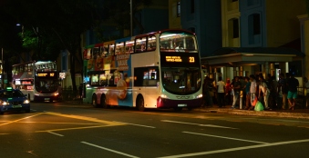
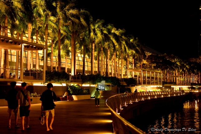
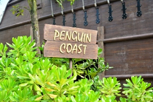
Singapore is an Island nation which is one of the few countries where the capitol is same as the country. It is around 750 square kilometers including all new reclamation, with the east-west length of around 40 km and north-south length of around 20 km. Here are some important facts for the first time travelers to the Garden Island, Singapore.

Visa

Singapore offers On-arrival visa  for many nationalities. You can check further details from following link. Make sure to keep the last part of the boarding document given as it may be required to produce whenever necessary. You can find the list of countries who have On-Arrival visa here.

Weather

Singapore has almost constant weather activities all around the year. As it is located near the equator the climate is bit warm. There will be a drizzle in the afternoon which will be over in about an hour, So better be prepared if you are planning to walk or visit a park. You can use an weather app just to make sure.

Transport

DSC_5247

Main three transportation methods in Singapore are MRT (Mass Rapid Transit), Buses or Taxis. Singapore highly promotes the usage of Public transport. Therefore, you can experience one of the best public transportation systems there. There are even driver-less MRTs. If you are planning to travel more on public transport, it is recommended to buy a Singapore Tourist Pass, which will save you a lot!

MRTs are the cheapest option for traveling. Singapore has a good train network, covering almost every place you need to go and it is further evolving. You need a ticket to enter the MRT platform. If you don’t have a Tourist pass you can purchase a ticket from the automated machines at each MRT station, which you still can recharge and reuse to get discounts on your 3rd and 6th rides.


DSC_5484

DSC_5107


Buses are the next cheap mode of transport. Traveling in the Buses will be tricky if you don’t have that re-chargeable card. Then you will need the exact amount of bus fare as there is no bus conductor. So better be aware of the bus fare and recheck your wallet for change before getting in on a bus.

Taxis are common in Singapore, but may cost you more than public transport. There are Taxi stands at common places where you can get one by being in the queue. Else you can use services like Uber.

Other than above modes of transport Walking and Cycling are the best ways to explore Singapore. Some places rent bicycles for daily basis. But with the hassle of  finding a place to safely park the bicycle I would prefer walking. Singapore has this amazing concept of sheltered walkways, which they said to have constructed shelters above more than 50% of the walkway length.

Communication

You can always use roaming facility of your mobile service provider. But I strongly suggest to purchase Starhub, Singtel or any other SIM which you can find every corner. They come with complementary Data allocation which you can use to make calls through Viber or similar methods cheaper than the standard roaming charges.

CultureDSC_5836

Singaporeans are generally very open minded people. They do not have conservative mindset like most of other Asian countries. There are many ethnic groups living together in peace and harmony. There main language is Malay, but all speaks English fluently. There are certain areas named according to the ethnicity of the people who live there. China town, Little India and Arab Street are examples. But Singapore encourages people to live as mixed ethnic groups, they even try to maintain the racial balance in apartment buildings! Singaporeans don’t try to talk much, but they are social and a kind crowd. They respect their elders and take special care of the young. They are very conscious about physical health and most of them spend their evenings in a gym, working out or in doing cardio in walking tracks.

Food

DSC_5239

Singaporean cuisines are rich as they have all Malay, Chinese and Indian influences. There are Open areas with many food stalls called Hawker Centers everywhere you go.  Singapore encourages small scale food stalls by low rentals on Hawker center food stalls, so that they can sell meals at a lower price. That way even people with lowest incomes can survive. There are all kinds of international food chains in Singapore, but people tend to give lower preference to those as they have many more to choose from. There are middle level restaurants that the price can be high as two times the Hawker center and small scale restaurant prices and High end restaurants that you can spend a fortune for a meal!

“Do”s and “Don’t”s

13006500763_1cb4f0977c_b

  1. Do offer your seat for elders, pregnant ladies and people with infants when you are traveling in public transport.
  2. Always use the pedestrian crossings or over passes to cross the roads.
  3. Always use the designated bins to throw garbage, else you will be fined.
  4. Singaporeans admire silence in Public transport, try not to shout.
  5. Don’t consume Chewing-gum as it is prohibited in the country, you will be fined.
  6. Don’t use or keep Drugs as it is prohibited. Singapore give death penalty to drug traffickers.
  7. Don’t eat or Drink in Public Transport, you will be fined.
  8. Don’t take Dooriyan to Buses or MRTs, you will be fined.
  9. Don’t leave tips at restaurants.

Must Visit Places

  1. Gardens by the Bay (Trip report will be uploaded soon)
  2. Marina by the Bay (Trip report will be uploaded soon)
  3. Sentosa Island (Trip report will be uploaded soon)
  4. Jurong Bird park
  5. Singapore zoo, River Safari and Night Safari (Trip report will be uploaded soon)
  6. China Town, Little India, Arab Street (Trip report will be uploaded soon)
  7.  Singapore Botanical Gardens and National Orchid Gardens (Trip report will be uploaded soon)

Special Articles

  1. Singapore Food Hunt (Trip report will be uploaded soon)
  2. Shopping in Singapore (Trip report will be uploaded soon)